The state is in a privileged geographical position, in the corner of the continent, the place of South America that is closest to Africa and to Europe, a strategic position during the second world war and also, nowadays in the international trade.
It is situated where the Brazilian coast changes directions, with a coast facing east and the other facing north.
The state area is 53.306 km2, which corresponds to 0,62 % of the Brazilian territory.
Situated between meridians 34į58'03" and 38į35'12" W and parallel 04į49'54" and 06į58'52".
The distance from east to west is 403 km and from north to south is 233 km.
.
The geographical advantages of the state
The geographical situation of the state is privileged :
The point of Latin Amťrica the closest to Europe and to Africa.
A coast 400 km long, with natural sites of great beauty, such as beaches, dunes, lakes and cliffs.
East coast : has a varied vegetation and is windy.
North coast: desert life and wild, it is sheltered from winds.
The state with help from its ambiental ressources has all the necessary conditions for both economical and touristical development.
80% of the territory is under 300 meters above the sea level. But the state possesses beautiful mountainous region (Serras), such as the regions of Sťrido and Martins.
The state has also e great number of lakes in the east coast and artificial lakes (aÁudes) in the countryside region.
Gťographico-tourist distribution of regions
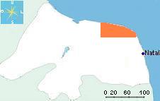
Region of Tibau do Sul - Pipa
strip of land with 15 to 25 km from west to east, and 55 km from the North (Tibau do Sul) to the south border of the state.
The region has a few density, the population is concentrated in some cities as Goianinha, Canguaretama and in villages mainly near the sea, such as Tibau do Sul and Pipa.
The coast consists of a succession of dunes and high cliffs with vegetation known as 'Mata atlantica'. The banks of the lakes and rivers are sometimes filled with a type vegetation known as mangrove swamps.
This region with 15 to 20 km from west to east and with 40 km from north to south, contains several valleys where lakes and lagoons have been formed and often surrounded with hills and sand dunes.
The seaside is occupied by long beaches and some creeks, with an exception in the North with the Tabatinga cliffs.
The important population density is mainly due to the nearness of Natal and the human concentration in important cities such as 'Parnamirim' and 'S„o Josť do Mipibu'.
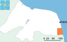
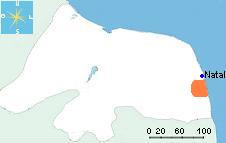
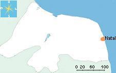
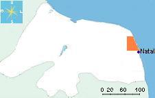
The Capital of the state, by its tourist importance and its 500 years of history represents by herself a region.
The city possesses a population of about 800.000 persons, 30% of the population of the state, with a strong human density in the north part of Natal. The city is limited in the East by the sea lined by a strip of dunes 'Park das dunas' with 12 km containing a reserve of 'Mata Atlantica' and on the West by the meanders of 'Rio Potengi' occupied by mangrove swamps.
In the South you can observe the Ponta Negra beach and its very high dune 'Morro do careca' and in the North the Genipabu dunes.
This region with a succession of 50 km of dunes and beautiful beaches of coconut palms, id bounded in the South by the beach of Redinha and the Genipabu dunes and in the North by the Rio do Fogo village.
The demoghaphic density is smaller in this region.
The population is grouped together in the cities of CearŠ Mirim and Extremoz, and with the presence of some fishermen's villages by the sea.
On the coast, you will observe a vegetation of dunes. The countryside possesses a small vegetation of 'Caatinga'.
This region of big beaches and dunes directed facing north from Touros, spreads out on a strip of about 100 km from east to west, from the beach of Perobas to Galinhos.
The demographic density is smaller because of a weak economic activity, its dry climate, mainly in the Western part.
The Eastern side where is situated the city of Touros is the corner of South American continent. The rest of the region has some fishermen's villages, which the most known are S„o Miguel do Gostoso and Galinhos.
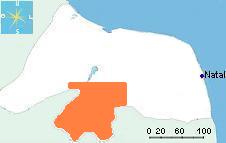
This region of more than 120 km a side, is bounded in the Northeast by the city of 'Cerro Cora', and in the Southwest by the city of 'Jardim de Piranhas', border with the state of CearŠ.
Region of artificial lakes, (AÁudes), it is strewed with small mountain ranges which gives it a special identity in the state.
The population is distributed in several middle cities from 10.000 to 42.000 inhabitants as Currais Novos, with also numerous spread villages.
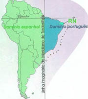
At the end of 15th century, the Spanish and the Portuguese, the kings of seas in this period, decided to divide up the exploitation of the discovery lands and search in the ocean, on the West of Europe.
For that purpose, they sign the Treaty of Tordesilhas of June 7th, 1494, that separates the space of occupation on an imaginary line, the Meridian of Tordesilhas that cuts the South American continent in two.
Taken possession of the Brazilian Northeastern lands
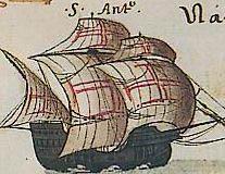
In 1501, Amťrico Vespucci, in the name of the Portuguese crown, comes to take possession of the Brazilian lands, discovery little time ago. With a fleet of 3 caravels, he approaches a beach of Rio Grande do Norte, called today beach of Marco, because of the mark of conquest left on this beach: the 'Marco de Touros'.
The original of this Brazilian History Heritage is exposed in the Fortress in Natal, 'Forte dos Reis Magos'. The replica is in the beach of Marco.
The birth of the Capitania of the Rio Grande do Norte
In the first half of the 16th century, the Portuguese owners of this Brazilian land, couldn't really occupy it because of the attacks of the Indians (in the region Cariris and Janduis), allied of adventurers and foreign pirates.
King of Portugal D. Jo„o III thus decides in 1534, to divide the Brazilian lands into lots given to the Portuguese captains, to maitain the domination and the ownership of lands by the Portuguese. Those lots were called Hereditarian Capitaincies.
The Capitaincies were on the west from the meridian line of Tordesilhas, which separates the lands annexed by Spanish and Portuguese until the Atlantic Ocean on the Est.
The capitaincy which later formed a state got the name of the river which crosses it, 'Rio Grande do Norte'.
The name of the river Potengi which meets the ocean in Natal comes from the Tupi language and means Shrimp 'Camar„o'.
Occupation and quarrel of the Rio Grande do Norte lands
It is only in 1597 that the Portugueses sent a new expedition to dislodge all the foreign intruders, then began the construction of a fort on January 6th, 1598 which they called, 'Forte dos reis magos'.
Later on December 25th, 1599, began the conctruction of the city called Natal.
In 1633, the fortress was attacked and conquered by the Dutch who introduced few later the production of the sugar cane culture.
The region has been on a period of a relative tranquility, soiled by confusions and massacres as the one of Cunhau in 1634, when had been implanted the first production of sugar cane and where numerous Portuguese colonists were murdered, then in 1645, the massacre of the colonists of UruaÁu by the Dutch.
The confrontations between Dutch and Portuguese supported by their respective indian allies, turned to the advantage of the last ones, in 1654, with the departure of the Dutch.
Development of the state
Development by the production of the sugar cane
Once the invaders were rejected, the Capitaincy remained without money, the development of the region crossed by the exploitation of the Indians Cariris which were forced to work in captivity in the fields of sugar cane. They revolted against the violence and the colonists had to give up imprisoning them. Afterward, the developers used the workforce of the slaves from Africa.
Farmlands good for the production of sugar cane were distributed to people with a certain influence with the King of Portugal and to the bosses of the Capitaincies (DonatŠrios). The concession was attributed according to the possibility of the use of lands and resources of the colonists, so creating the conditions in the economic and demographic growth, with the foundation of cities and villages, modifying the way of living of the populations which lived until that moment from hunting, fishing and collecting fruits.
The economic, military and political powers were then concentrated in the hands of these rich developers. The setting-up was progressive and reached more than 170 plantations in the state.
Development of the countryside by the breeding
The first farms 'Fazendas' were of breeding mainly of cattle, but also tackles and poultry. They been born by the demand of the sugar cane activity and was implanted in the countryside, the 'Sert„o', (Big Desert) at the beginning of the 18th century, and placed according to the presence of rivers, streams, lakes and water sources. They are the origin of the occupation and the populating of the countryside of the state, 'Sert„o' and 'Agreste'.
The growth of the cattle, asked for a structure of support by relays of rest and food to supply markets and plantations of the coast. These relays help to create some cities in the countryside, 'Currais Novos' is one exemple.
Intensification of the countryside populating by the culture of the Cotton
The populating of the state countryside became intensified in the second half of the 18th century with the exploitation of the cotton, breathed by a strong demand of the English textile industry.
The cotton was well adapted to the semi-arid ground and the plantations were fastly spread, making the replacement of the breedings by the cotton fields.
This culture brings also an important stream of the population. The businesses and the markets created around this activity allowed the transformation of villages to cities such as the city of Mossorů.
Other cultures as corn, black and green bean, cultivated in association with the cotton supplied the food complement for people and cattles.
Modern history
The communism in 1935
In the political history of Brazil, Natal was the unique capital of the country which in 1935 was dominated by the Communists. During 4 days, the capital Potiguar was under the orders of the Revolutionary Popular Committee, which managed to publish a newspaper and to send to people a 'manifesto'.
The aviation history
Augusto Severo, born in MacaŪba, in 1864, knowned internationally such as pioneer of the aviation beside Santos Dumont, and died in Paris, in 1902, in the explosion of the dirigible Pax, which he had built.
The privileged place of the state made it a stage in the beginning of the aviation history, particulary with the french airmail 'aťro postale'. Jean Mermoz, French airman, who in 1930, made the first airlift of a line by leaving Saint Louis (Senegal) to arrive at Natal.
The second world war
During the period of the 2nd world war, by its geographical situation in front of Africa, Natal sheltered the biggest American air base outside the United States, base of Parnamirim, known by the name 'Springboard of Victory'.
In 1941, with the presence of German on the African continent, the American President Franklin Roosevelt meets the Brazilian president Getķlio Vargas in Natal which was the ideal place for the construction of an air and naval base.
With approximately 55 thousand inhabitants, the city was quickly transformed with the arrival of the Americans.
The plan Real
The plan 'Real (R$)' was a project of stabilization of the economy developed by the ministry of economics during the government of Fernando Henrique Cardoso, president elected representative in 1994. The main success of the plan was the control of the inflation.
The rates of inflation had dropped from 4 digit the year to rates in 1 digit the year. The inflation of practically 2500% in 1993 arrived at 8,64% in 1999. It is from this moment that the state of Rio Grande do Norte began to know a strong economic and tourist development.
>> More


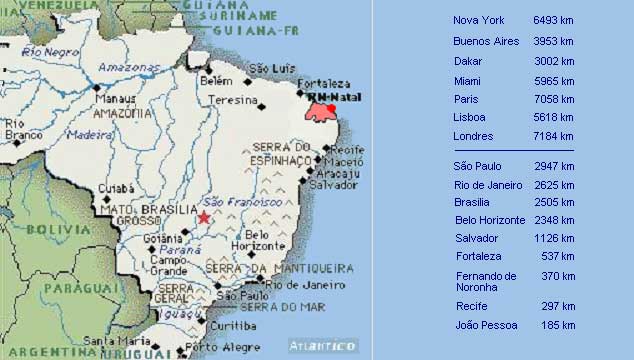
 The point of Latin Amťrica the closest to Europe and to Africa.